
5 Shots Every Real Estate Listing Needs from Above
Buyers expect aerial photos now. Here are the five drone shots that make listings stand out, sell faster, and close for more.
If you're a real estate agent in 2026, aerial photography isn't a bonus — it's a baseline expectation. Over 80% of agencies now use drone photography to market properties, and 57% of buyers expect to see eight to ten aerial images per listing. Properties that include aerial shots sell 68% faster and see 61% more clicks online than those that rely on ground-level photos alone.
But not all aerial shots are created equal. Flying a drone up and snapping a few photos from random heights won't move the needle. The agents getting the best results are working with their drone photographers to capture a specific set of shots — each one designed to answer a different question a buyer is asking as they scroll through a listing.
Here are the five aerial shots every listing needs and why each one matters.
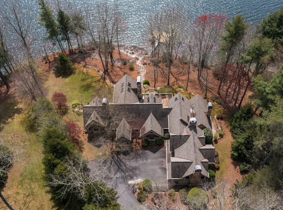
1. The Hero Shot: Front Elevation at Mid-Height
This is your listing's first impression from above, and it's often the shot that stops a buyer mid-scroll.
The front elevation is taken from roughly 15 to 30 feet off the ground, with the camera angled slightly downward toward the property. It's high enough to feel elevated and distinctive, but low enough to preserve the human scale of the home. From this vantage point, buyers can take in the roofline, the front entry, the driveway, landscaping, and the overall curb appeal — all in a single frame.
This oblique angle, typically around 45 degrees, gives the home a sense of depth and dimension that flat, ground-level photography simply can't achieve. It shows the architectural character of the property the way the builder intended it to be seen. For many listings, this becomes the lead image — the one that appears in search results, email blasts, and social media shares.
Pro tip: Shoot this during golden hour — the soft, warm light shortly after sunrise or before sunset — for the most flattering result. Harsh midday sun creates strong shadows on rooflines and washes out landscaping color.
2. The Bird's-Eye View: Straight Down Over the Property
Sometimes called a nadir shot, this is a vertical photograph taken from directly above the home, with the camera pointed straight down at 90 degrees. It strips away perspective entirely and shows the property as a clean, map-like overhead layout.
This shot answers questions that buyers can't resolve from the ground: How large is the lot? Where does the property line end? How does the house sit on the land? How far is the nearest neighbor? What's the relationship between the house, the garage, the driveway, the backyard, and any outbuildings?
For properties with pools, patios, sport courts, gardens, or other outdoor features, the bird's-eye view is essential. It gives buyers a clear, honest sense of scale and spatial arrangement that no ground photo can communicate. It's also the shot that agents report getting the most questions about from sellers — because most homeowners have never seen their own property from this perspective.
Pro tip: Pay attention to symmetry and alignment. Position the home centered in the frame, with the edges of the property running parallel to the image borders. A well-composed nadir shot looks clean and professional; a crooked one feels sloppy.
3. The Neighborhood Context Shot: Pulling Back to Show Location
Real estate has always been about location, and this is the shot that sells it.
Taken from a higher altitude — typically 100 to 200 feet — the neighborhood context shot pulls back to reveal the property's relationship to its surroundings. It shows nearby parks, schools, bodies of water, commercial areas, golf courses, trails, cul-de-sac positioning, or whatever geographic features make the location desirable.
This is the shot where a lakefront home actually looks like a lakefront home. Where the proximity to downtown becomes visually obvious. Where a buyer browsing from out of state gets an instant, intuitive sense of the neighborhood — without needing to zoom around on a map app.
For suburban listings, this shot contextualizes lot size relative to neighbors and shows community features like pools, playgrounds, and walking paths. For rural properties, it showcases acreage, tree coverage, and privacy. For urban properties, it establishes proximity to landmarks and transit.
Pro tip: Don't fly so high that the property becomes a dot. The home should still be identifiable in the frame — consider having your drone photographer place a subtle indicator or ensure the property is clearly centered so the viewer's eye is drawn to it immediately.
4. The Feature Spotlight: Low-Angle Close-Up of the Best Asset
Every property has at least one feature that deserves its own moment from the air — and this is the shot that delivers it.
The feature spotlight is a lower-altitude, closer-range aerial shot — typically 10 to 25 feet off the ground — that isolates and highlights a specific selling point. This could be a luxury pool and outdoor kitchen, a wraparound porch, a rooftop deck, a detached workshop, an expansive patio with a firepit, mature landscaping, or a unique architectural element like a turret or a multi-level roofline.
While the other shots in this list focus on the property as a whole, the feature spotlight zooms in on the detail that makes a buyer say, "I want to live there." It brings an architect's vision to life and gives proper visual weight to the upgrades and amenities that drove the listing price.
This is also the shot that performs best on social media. A dramatic low-angle aerial of a sparkling pool surrounded by hardscaping, captured at golden hour, is the kind of image that generates shares and saves — expanding the listing's reach far beyond the MLS.
Pro tip: Walk the property with your drone photographer before the shoot and identify one or two features worth spotlighting. Planning this shot in advance — rather than improvising during the flight — produces dramatically better results.
5. The Cinematic Reveal: A Short Video Flyover
Still photography is powerful, but video is what makes a listing unforgettable. Industry data shows that listings with video content generate 403% more inquiries than those without, and 39% of buyers now consider virtual tours and video walkthroughs among the most useful features on a real estate website.
The cinematic reveal is a short drone video — typically 30 to 60 seconds — that approaches the property from a distance and gradually draws the viewer in. The classic movement starts with a wide establishing shot of the neighborhood, then glides forward and descends as the home fills the frame, often finishing with a slow orbit around the property or a gentle rise that reveals the backyard and surrounding landscape.
This creates a visceral sense of arrival — the feeling of driving up to the home for the first time. For out-of-town buyers who may not be able to visit in person before making an offer, this flyover can be the deciding factor that moves them from browsing to scheduling a showing.
Even a simple, well-executed flyover sets a listing apart. It signals to buyers — and to sellers evaluating potential listing agents — that the marketing behind this property is professional, modern, and thorough.
Pro tip: Keep it short and smooth. A 30-second flyover with one or two clean camera movements is far more effective than a two-minute video with jerky pans and constant altitude changes. Quality of motion matters more than quantity of footage.
Putting It All Together
These five shots work as a system. Each one answers a different question for the buyer.
The hero shot says, "This home has great curb appeal." The bird's-eye view says, "Here's exactly what you're getting." The neighborhood context shot says, "And look where it's located." The feature spotlight says, "Wait until you see this." And the cinematic reveal says, "Imagine pulling up to this every day."
Together, they create a complete aerial story that drives engagement, builds buyer confidence, and ultimately accelerates the path to an offer. Listings that include this full package see up to 65% more in-person showings and are 67% more likely to be shared on social media — putting your property in front of buyers who might never have found it otherwise.
A Note on Working with Your Drone Photographer
The best results come from collaboration. Before the shoot, share the listing's key selling points, the price range, and the target buyer profile with your drone photographer. Walk the property together if possible and discuss which features deserve the most attention.
Timing matters too. Different seasons highlight different strengths — lush summer landscaping, dramatic fall foliage, or the clean lines of a property against a winter sky. Scheduling the shoot to align with when the property looks its best is a small detail that makes a big difference.
And finally, make sure your photographer is FAA-certified and insured. Professional aerial photography isn't just about image quality — it's about compliance, safety, and the credibility it lends to your entire marketing package.
Carolina Aerials LLC works with real estate agents across the Carolinas to capture the full suite of aerial listing photography — from hero shots to cinematic flyovers. Every shoot is tailored to the property and designed to help your listings sell faster and for more. Contact us today to book your next listing shoot.
Ready to Elevate Your Listings?
Professional aerial photography for real estate agents across SC, NC, and GA.
Schedule Your Shoot